Source: Italian Space Agency (ASI), 29/09/2025
At the Sos Enattos mining site in Lula, the new geodetic infrastructure, built by the Italian Space Agency (ASI), has been completed to support the construction of the Einstein Telescope (ET). ASI personnel coordinated all scientific and technical activities, with the technical and operational support of e-GEOS S.p.A. This marks a decisive step in mapping the area and preparing for the large gravitational wave observatory planned under the ETIC project. To this end, ASI planned and coordinated the installation, assembly, and testing of three GNSS stations at appropriately identified (Figures 1 and 2), as well as the execution of a gravimetric survey.
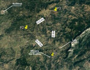
Figure 1) Locations identified for the installation of GNSS stations.
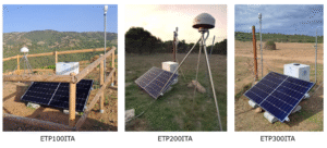
Figure 2) The three GNSS stations.
In the disused Sos Enattos mine, a gravimetric survey was carried out using ASI’s FG-5 absolute gravimeter (Figure 3). For 24 consecutive hours during the last week of May, the instrument precisely recorded the local gravity field, collecting valuable data to gain in-depth knowledge of the site’s characteristics and to ensure the stability conditions required for the future construction of the Einstein Telescope.
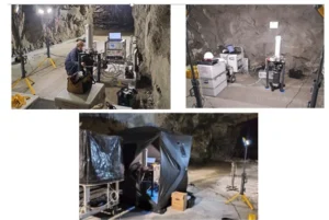
Figure 3) Preparation of the gravimetric site and installation of the measuring instrument.
The new infrastructure, which will become fully operational by the end of 2025, is already integrated into ASI’s National GNSS Fiducial Network, whose Monitoring and Control (M&C) center is located at the ASI National Facility in Matera, “Giuseppe Colombo” Space Center. All functionalities, including data transmission, have already been successfully tested, and once the infrastructure is fully operational, the data will be made available to the national and international scientific community through GeoDAF, ASI’s archiving and dissemination system.
The activities to be carried out with the new infrastructure will enable the creation of a geodetic reference network and the development of a detailed geological model of the area. These data will be essential for optimizing the placement of the Einstein Telescope’s underground infrastructure and for ensuring maximum stability and precision during its construction.
Once the Einstein Telescope is operational, the geodetic network will continue to play a crucial role: it will allow real-time monitoring of any ground deformations or movements, ensuring the reliability of scientific measurements while also offering new research opportunities in the fields of geodesy, geophysics, and environmental monitoring.
With the completion of these activities, ASI further strengthens its national infrastructure for geodetic monitoring through its own project, supporting scientific and technological activities in the field of environmental monitoring.